

Purple Mountain [An Sliabh Corcra]
Good walks are even better shared.
V8885 : Cairn on Purple Mountain
Colin Park Photo source
Overview
Purple Mountain [An Sliabh Corcra]
Purple Mountain is an 832 m summit in County Kerry, in the massif east of the Gap of Dunloe. The Gap separates it from the main Macgillycuddy’s Reeks ridge. The broad DoBIH section label includes both areas; that catalogue grouping does not put the summit on the Reeks ridge. Primary record · Landscape names
The recorded summit feature is the shelter, higher than the cairn about 70 m northeast. Tomies, Purple Mountain NE Top and Shehy are distinct companion summits.
Access must be confirmed
Hiking Club Ireland quotes Irish Peaks (2020), which advised against the classic Tomies–Purple–Gap loop because of an access problem. Mountaineering Ireland’s Summer 2022 notice asked walkers to report difficulties on Purple or Tomies. A Dingle Hillwalking Club outing dated 21 June 2026 documents a circuit, but does not confirm general permission or resolve those earlier warnings. No current resolution was established in this review. 2020 quotation · 2022 primary notice
The conditional 16.5 km route record follows that club’s full circuit from Kate Kearney’s via Tomies and Purple, descending by Glas Lough and returning along the Gap road. It is not a leisurely walk from Killarney. Confirm current access before planning it. The quoted distance does not include an added Shehy excursion. Club route
Steep and faint paths, wet rock and bog require navigation and mountain equipment. Do not shortcut directly to the road across steep, craggy slopes. The older guide’s parking prices and transport details have not been treated as current. Terrain and descent warning
Landscape and names
The National Park guide identifies Purple Mountain as Old Red Sandstone, not schist and granite. Geology
An Sliabh Corcra means the purple mountain. Tempan considers it probably a back-translation of an English name and records earlier Tomies usage for the massif. Name history
Sources checked 18 October 2026. The existing 832 m elevation, 595 m prominence, imported Abney-level survey and 2023 revision remain unchanged.
Explore routes near Purple Mountain [An Sliabh Corcra]
Walks starting near this hill. Open a route to check its map, distance and full itinerary.
Route planning notes
These notes describe possible approaches. Check a route's map and access information when planning your walk.
Tomies–Purple circuit: access confirmation required
Conditional route record, not confirmation of an open public route. The club outing dated 21 June 2026 lists 16.5 km from Kate Kearney’s: north approach, Tomies, Purple, Glas Lough, Head of Gap and road return. A 2020 access warning remains unresolved in the sources checked; confirm current access before planning. The club outing is not general permission. Source: https://dinglehillwalkingclub.com/purple-tomies-killarney/
Make a day of it, together
Find someone to share the walk with, or organise a day out along a route you like.
Photo Gallery
View all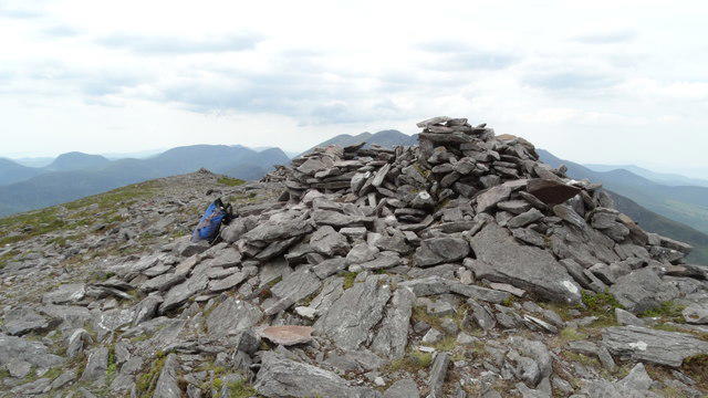 Photo could not load
V8885 : Cairn on Purple Mountain
Colin Park
Hill facts and local notes
Classifications
Elevation
832m
2,730 ft
Prominence
595m
Coordinates
52.0079, -9.6225
V886851
OS Map
78
At the Summit
DoBIH identifies the shelter at V8863985173 as the summit feature, higher than the separate cairn about 70 m northeast at V8868885217. The nearby cairn is not the recorded highest point.
Terrain & Geology
Purple Mountain is part of the Devonian Old Red Sandstone landscape described in the National Park’s geology guide. Glaciation shaped the surrounding valleys. The schist-and-granite description is unsupported.
Views & Scenery
From the summit, you can spot the Lakes of Killarney, the distant Slieve Mish Mountains, and the rugged peaks of the Macgillycuddy's Reeks.
History & Heritage
Name Origin
An Sliabh Corcra translates to 'the purple mountain' in Irish, reflecting its distinctive colouring.
Historical Significance
Paul Tempan’s Irish Landscape Names traces earlier Tomish or Toomish usage to the wider massif and considers Purple Mountain an English coinage, with An Sliabh Corcra probably a later Irish back-translation. This is an attributed naming interpretation, not evidence for unspecified local folklore.
Getting There & Facilities
Parking
The documented circuit starts by Kate Kearney’s Cottage at the northern entrance to the Gap of Dunloe. A 2012 guide describes parking opposite; check present signs, availability and terms. Do not assume parking at the Head of the Gap is acceptable: the quoted 2020 guidance asks walkers not to park there. Confirm mountain access separately.
Public Transport
No current scheduled service to this circuit’s Kate Kearney’s start was verified. Plan and confirm an outward and return connection separately; reaching Killarney or a National Park visitor centre does not establish transport to the mountain route.
Nearby Facilities
Killarney offers a range of facilities, including cafes, pubs, and public toilets, ensuring you can refuel before or after your hike.
Safety Information
Known Hazards
- Access is unresolved in the sources checked on 18 October 2026. Hiking Club Ireland quotes a 2020 warning against the classic Tomies–Purple–Gap circuit; a 2022 Mountaineering Ireland notice sought reports of difficulties. The June 2026 club outing does not establish general permission. Confirm current access before setting out.
- Steep, rough and sometimes faint paths, boggy ground and slippery rock require mountain navigation skills, suitable equipment and a weather assessment.
- Do not descend directly from Purple Mountain to the Gap road: the 2012 route guide warns of steep rocky ground and crags absent from its map.
- The Gap road is shared with jarveys, cyclists and other users. The quoted 2020 guidance asks walkers not to drive through it or park at the Head of the Gap.
General Safety Tips
- Check weather conditions before setting out
- Carry appropriate clothing and equipment
- Let someone know your planned route
- Take a map, compass, and GPS device
- Carry emergency supplies: food, water, first aid kit, torch
Hills
Some common questions about the hills answered
Are there group walks up Purple Mountain [An Sliabh Corcra]?
Many walkers use Walkmates to join or organise walks with others. You can check for group walks around Purple Mountain [An Sliabh Corcra] through the maps
Are there other walkers around Purple Mountain [An Sliabh Corcra]?
Activity varies by location and time, but Walkmates lets you see whether others have shared walks or shown interest in this area. Find other people through the walking friends search walking friends for Purple Mountain [An Sliabh Corcra] search or of course create your own walk for Purple Mountain [An Sliabh Corcra]
Can I organise a walk to Purple Mountain [An Sliabh Corcra]?
Yes. If there aren’t any walks listed already, you can create a walk and make it available for others to join.
If you're signed up to Walkmates, you can create a walk to Purple Mountain [An Sliabh Corcra].
How do I find a walk up this hill?
There are often multiple ways to walk this hill, depending on experience and route preference. Walkmates helps you explore walks and routes that others have shared.
Can I suggest a new route up Purple Mountain [An Sliabh Corcra]?
Yes. You can suggest or create routes to share with others. Walkmates focuses on the social side of walking, so routes are used to help people organise walks and explore areas together, rather than as detailed navigation tools or route libraries.
Other uses really appreciate knowledgeable walkers sharing their routes. Share your favourite route to Purple Mountain [An Sliabh Corcra] here
The is an error or something incorrect about this hill. How do I let you know?
We always strive to keep the information on Walkmates as accurate as possible. If you find an error, please let us know through the contact form and we'll aim to correct it as quickly as possible
Community Discussion
Comments
Location
View the hill's mapped position and surrounding paths.
Grid reference: V886851
View on OpenStreetMapOpens a map in a new tab, centred on the hill.
No comments yet. Be the first.